Tahoe Rim Trail - Kingsbury Grade to Eagle Falls
The Final Segment of My Tahoe Backpacking Experience
Image Source: "Lake Aloha" by Jonathan Fox - Under Creative Commons License
My friend Kelly invited me to stay at her home for one night in Northern Reno before I got on the trail again for one last time.
I began in the late afternoon and only got a couple miles in before the sun started to set. This section of the trail starts out climbing past the chair lifts at Heavenly ski resort. I setup camp behind the resort, nearby a water source and got some good rest again sleeping on the mountain.
Day 1
After a zero day in Reno I was feeling pretty well rested again and pushed hard again. I hiked all the way to Star Lake. Many people consider Star Lake one of the best spots on the whole trail and its a popular location to camp. I stopped to eat lunch here where I saw my first ever bald eagle fly overhead and I learned of the tenacity of Tahoe's rodent residents.
I had placed my pack about 30 feet away from where I was sitting. As I ate my lunch I noticed two chipmunks were quite interested in my backpack and had started to chew a hole into a ziplock bag filled with snacks. I tried to shoo them away by shouting and throwing rocks. They would dart away behind a tree, and then come back again. I tried hopelessly in this fashion for a minute until it became quite obvious they were never giving up.
So I stood up and relocated myself next to the bag. The chipmunks never left, and even tried sneaking up on me still, despite the fact that I was sitting right next to my stuff. Only then could I be sure my snacks were safe!
With a couple other campers at the lake, I couldn't find a secluded spot I liked that wasn't right next to the trail, so I decided I would press on ahead.
Little did I know the most difficult section of my whole three weeks thru-hiking lie just ahead past the lake.
The trail connecting Star Lake to the base of Freel Peak rises from 9200 feet up to 9500 feet on a north facing slope. In the middle of June, this section was completely covered in snow still. The trail disappeared, and I found some sets of tracks leading into the snow, but even those disappeared too. I wondered if anyone had crossed through here before me, and I too thought about turning back. But my relentless determination to push forward got the best of me, so I strapped on my microspikes, and began cutting steps into the snow with my boots to try and get some purchase.
Progress was painfully slow and difficult. Just when I was starting to find my rhythm, I lost my balance, and fell. I slipped down for a second or two about fifteen feet, but it felt so much longer than that. My slide ended when my feet dug into a snowy tree well, and I stopped to regain my composure. I looked down the slope which continues for almost 500 feet below until it reaches a depression. I shuddered to think about the possibility of slipping down and crashing into a tree or rock at greater speed and resolved myself to continue on with the hike.
I had to break trail through at least 500 feet of snow like this until I finally started to hit dry patches again. Exhausted after trudging through here, suddenly camping at Star Lake seemed like would've been a pretty good idea. But I had already made it through and while there were still large section of snow ahead on the trail, nothing would ever come close to the challenge of getting past Star Lake. In total I hiked about 12 miles that day.
I made my camp at the base of Freel Peak. At about 9500' it was the highest elevation I camped at on the trail. I was so exhausted, and so proud of myself for getting to this point. Although it was cold and really windy up there, I slept so well!
Day 2
The next day I made good progress again, over ten miles to to Big Meadow Campground. Since I left Star Lake, I didn't see anyone else until making it over Armstrong Pass. This gave me about 24 hours completely alone on the trail, and even then, I only saw two other hikers until I descended to Big Meadow. In my solitude I was no longer confined to my thoughts and often began speaking out loud, not only to myself, but in conversations with the trees too. They were such great listeners!
I had planned to stay at Big Meadow that night, and I didn't expect to see so many people. It was the most crowded campground I passed on the trail, and it was completely full! Tired after my day of hiking, I approached a group of young people around my and asked if I could share the space at the campsite with them. They graciously brought me into their circle. They were from the bay area, and had come to the Sierras for a weekend of rocking climbing. We played board games, sat by the campfire and shared stories. These moments on the trail talking with other people were a sharp contrast with my miles alone hiking and I enjoyed the society of people just as much as my hours of solitude.
The more time I spent alone, the easier it was becoming to be by myself, and also taught me to enjoy the company of other people that much more.
Day 3
I skipped the next 18 miles of the rim trail and took a detour up Hawley Grade which connects back with the highway near Echo Summit. It was father's day, so I sent my dad a message and a picture of my location. He shared it to Facebook, so this makes it the only photo I have saved from this trip.
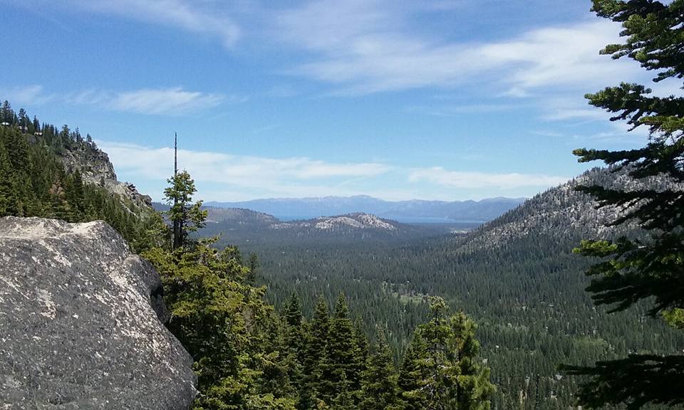
View of Lake Tahoe from Echo Summit - by Joshua Gibbs
From the summit I descended down to the Echo Lakes Trailhead and parking lot. There were so many cars! From here the trail enters into the Desolation Wilderness, a popular destination of craggy peaks and glacial lakes. With close proximity to Sacramento, amazing scenery, and easy access from the highway its easy to see why entry to this area is by permit use only.
There were many hikers in this area including northbound Pacific Crest Trail thru-hikers. I passed by Echo Lakes and stopped to setup camp at Tamarack Lake. I enjoyed soaking my tired feet in the cold water here and got another great night sleep.
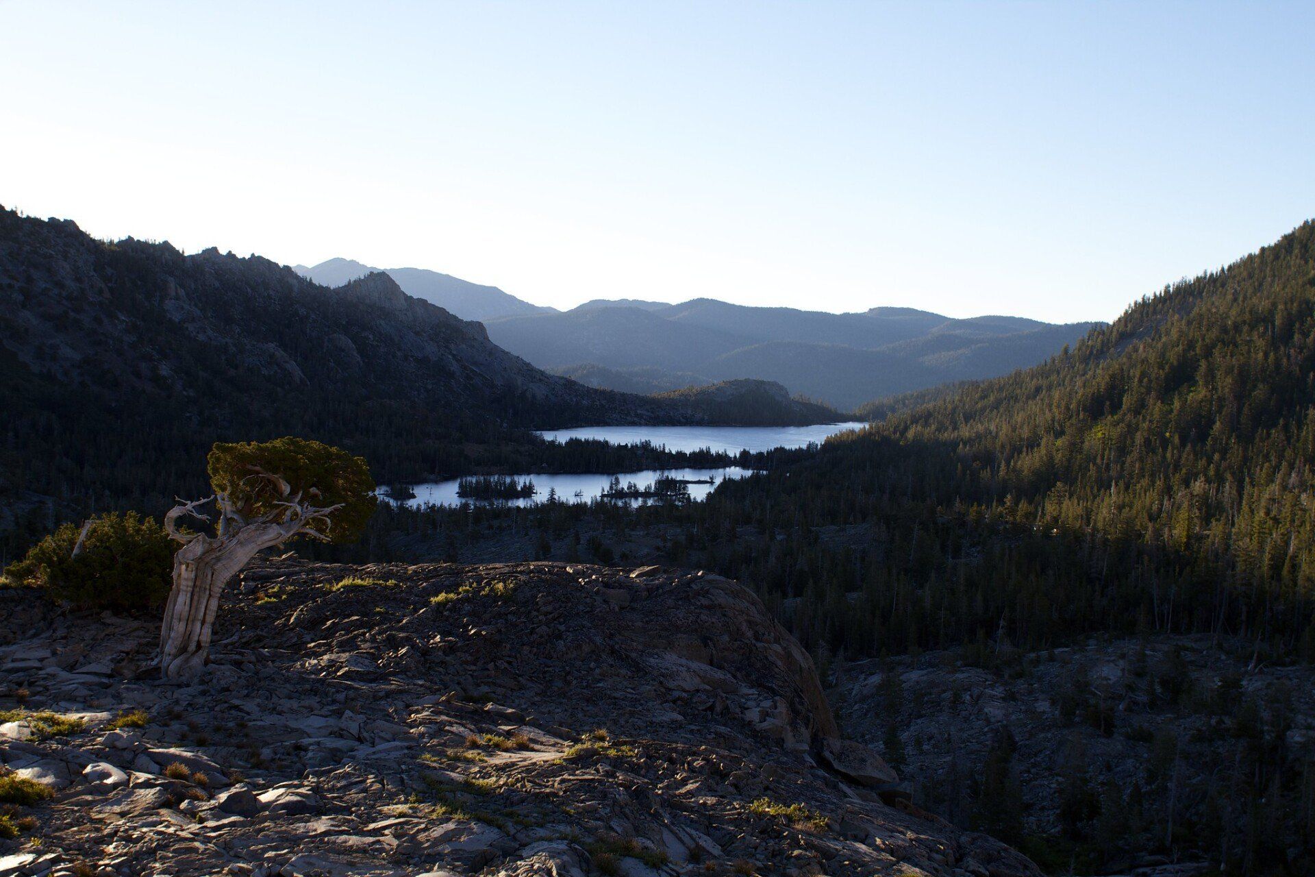
Image Source: "Echo Lakes" by Jonathan Fox - Under Creative Commons License
Day 4
After Tamarack Lake the trail disappeared into the snow again, but I had little problem navigating through. I passed Lake Margery and the view started to open up as the forest thinned out. I was hiking across granite, scoured smooth by ice age glaciers of the past. Here I encountered what seemed to be very large chipmunks. I would later on learn that these were marmots. There were so many of them!

Source: "Tamarack Lake Overnight" by Mitch Barrie - Under Creative Commons License
A little bit farther and I came to Lake Aloha, the crown jewel of Desolation Wilderness. This is a big lake, filled with a lot of little islands and absolutely gorgeous. The edges were still frozen and the were thick shelves of snow surrounding the eastern shore. After the the grandeur of the king of Sierra Nevada lakes (Lake Tahoe), Lake Aloha ranks at the top of the greatest lakes I've ever visited. I rested by the lake, feeling envious of two friends sharing the time together.
I continued on and stopped again near Heather Lake where I met a father with his two daughters and his dog. He told me a story about getting ripped off by his business partner who started the successful Mountain Hardwear company and a near death experience hiking Mt Shasta when his crampons suddenly lost their grip as he was standing still.
Next on the trail was Susie Lake, which stunned me by its picturesque beauty. Everything was so perfectly arranged, it looked like a painstakingly manicured classical Chinese garden.
From there I gave my last big push of the trip, hiking up Dicks Pass which gave me a view of Dicks Lake and Fontanellis Lake below where I would spend my last night on the trail.
I located a particularly beautiful campsite at Fontanellis Lake, hidden from the trail with a great view of the lake and the mountain crest behind it. At that moment I actually did not realize it would be my last night on the trail.

Source: "Dicks Pass 1" by Daniel Parks - Under Creative Commons License
New Paragraph