Tahoe Rim Trail - Galena Creek to Kingsbury Grade
Bushwhacking and Climbing 2600 Feet Back to the Tahoe Rim Trail
I started this trip at the Galena Creek Regional Park. My plan was to start hiking the TRT at Mt Rose Summit. James gave me a ride to Galena Creek where I spent the night in my tent near the snow removal service building.
Day 1
In the morning I was surprised by a hiker with his two German shepherds which came up to my tent to say hello. After packing my bag I tried hitchhiking to the summit. I put out my thumb and about 20 cars passed. Nobody stopped for me so I gave up and decided to hike up to the summit myself.
I followed the Old Mount Rose Highway which is a paved road in poor condition that seems to no longer be maintained. It winds through a few residential communities, past sky tavern ski resort before making its way up towards Mt Rose Summit. Somewhere along the way I lost the trail and began bushwhacking through some heavy growth.
Sometimes the plants were so thick I couldn't pass and I was constantly searching for the way to continue. Progress was extremely slow.
I crossed over a fallen log and lost my balance. I fell on my hip, bounced off the log, and landed on my backpack. I was shocked by this slip, considering how easily such a fall could lead to a broken bone or worse. I removed my pack and stopped to regain my composure before continuing on.
Uphill from me back towards the highway the growth was so thick I could not find a way back, so I decided I would follow Galena Creek uphill towards Galena Creek Falls.
Eventually I couldn't find a way to continue this direction either without crossing Galena Creek which tumbled over rocks and was moving very quickly. I came to one point where the creek was narrower and with a great push I jumped across to the other side.
From here the trail opened up and I contended with some snow fields and boulder hopping. I made it to the falls finally got back onto the trail. The trail however was almost completely covered in snow here so my progress was still very slow.
Finally at Mt Rose Summit I found a suitable campsite just outside the designated Mt Rose Summit campground.
By this point I was exhausted. I had hiked over 7 miles and 2600 feet of elevation gain. While more than half of this hike was along the paved Old Mt Rose Highway, the remainder of it was cross country, bushwhacking, and hiking through snow. These conditions were some of the toughest I would face on the whole hike, and certainly one of the most demanding hikes I've ever done, despite the relatively short distance.
Day 2
I woke up in the morning feeling pretty bad. My knee was still swollen from the previous day and I could barely walk, even without carrying my pack. I decided to take a day to rest at the summit. I spent most of this time doing some light exercises, meditating, and worrying about anything and everything possible.
What am I doing with my life? Why am I out here alone like this? How will I ever learn to make money and support myself? What's going to happen with Gregg's estate? Am I going to get any money? Why can't I ever find peace in my life?
The physical exertion required by backpacking forces me to stay focused, however, when I stop moving as I did at Mt Rose Summit I am flooded with overwhelming fear and anxiety like this.
Equipped with skills I had learned from my yoga teacher training I did what I could to stay relaxed and get through the day at camp.
Day 3
After a day of rest I woke up early just as the sun was started to give the sky a shade of dark blue. I was overwhelmed with incredible feelings of gratitude that I could experience something like this, after the extraordinary effort needed to set on such a trip alone.
I hiked through the quickly melting but still half frozen Tahoe Meadows with the plan to see the sunrise pour light onto Lake Tahoe. This idea quickly unraveled once I crossed the meadow and the trail headed into the forest. Here the trail disappeared under the snow which completely covered the ground by now. I stopped to consult my map and my phone numerous times to make sure I was headed in the right direction.
Without any obvious landmarks finding my way through the forest was so much harder than I realized. But I kept on pushing and eventually made it through for another glimpse of Lake Tahoe. I stopped for a rest and noticed just how cold it was once I stopped moving.
From here the trail was mostly downhill, with alternating stretches of dry and snow covered trail. I suppose I took my microspikes on and off at least 4 times on this part.
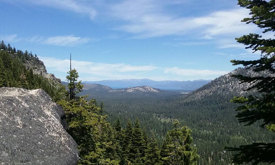
I passed by Diamond Peak which offered a stunning view of Washoe Lake to the east, and Lake Tahoe to the west, one of the only sections on the rim trail that offers a view like this.
Since I was a pretty wet winter and still early June, I was expecting to refill my water at Twin Lakes. But I was so disappointed to discover the lakes were completely dry. Not even a mud puddle left!
A wave of fear washed over me as I thought about where I would get more water. As soon as I came across more snow, I melted some to refill my bottle. The snow was pretty dirty, but I had no choice, and surprisingly the
water tasted really good still.
After the hot dusty switchbacks over Twin Lakes I arrived at the trail for Christopher's loop. This is the most photographed section of the rim trail. I had no idea at the time, but by looking at my map I figured I would get a great view. Rather than hiking the actually loop trail itself I climbed to the top of Herlan's Peak, which commanded an incredible view of Lake Tahoe. I should've been able to enjoy something like this more, but I couldn't stop worrying about everything.
Just past Herlan Peak the trail climbs a gradual slope into a meadow that overlooks Marlette Lake and Lake Tahoe. Here I saw a herd of twelve deer grazing several hundred feet from me, and a large thunderstorm across on the west side of the Lake Tahoe. If there was a single moment to capture the beauty of the entire rim trail backpacking trip, this would be it.
I camped at Marlette Peak Campground where I greatly enjoyed using the water pump. This was the first day where I didn't have to filter my water before drinking! What a relief that was. This was the longest distance day on the rim trail trip for me. I felt proud for hiking about 15 miles especially as I could hardly walk at all the day before.
Day 4
Because of the convenience afforded by the water pump, I considered spending a second night at Marlette Peak Campground. However; I still had such great difficulty sitting still with myself I continued to soldier on in my journey. That morning I spoke with another hiker at the campground. He was old enough to be my dad's age. He flew from Virginia out to hike a section of the rim trail. He shared some coffee with me and I enjoyed the moment talking with someone wiser and more experienced than I was.
This day I took a detour from the TRT and hiked down the road to Marlette Lake. Here I met a group of three backpackers younger than me. We stopped together for a break at the south end of the Lake. My hike ended this day at North Canyon Campground, with a lovely creek to refill water, and tables and firepits.
I had enjoyed a few days sober on this second section of the hike. The three boys had brought a large bag of weed with them and were quite happy to share with me. Over halfway through my rim trail hiking experience, I was finally getting moments of peace even when I stopped to rest. This night in North Canyon was a huge relief from the anguish and anxiety I had been going through. Of course all the problems still loomed in my mind. But at least for now I could just enjoy the beautiful scenery and kind, jovial companions.
Sharing stories and joking with each other. I truly felt at ease with this group, they were they kind of people I could imagine a friendship developing with. Imagine that! I was started to think I could have new friends again. It seems the backpacking trip really was having a positive effect on me.
Source: "Kingsbury Grade to South Camp Beach" by Jeff Moser. Under Creative Commons Use
Day 5
I considered rejoining the rim trail from North Canyon, but the thought of hiking up 1.5 miles of switchbacks was thoroughly unappealing to me at that moment, so I remained on the dirt road which led me back to Spooner Lake. I had stopped nearby here with Gregg a couple times, and had come hiking in this area the summer last year so it was nice to be returning to familiar territory. I refilled my bottles from the water pump at Spooner Lake, crossed over Spooner Summit and hiked up the trail to South Camp Peak. This was another short day of hiking for me as I got a late start from North Canyon and stopped for a long rest at Spooner Lake. In total about 5 miles.
At South Camp Peak I found a suitable clearing to set my tent and looked out over the Lake for amazing sunset over Lake Tahoe. It was cold, and really windy, but I stood outside until the sun had completely dropped behind the mountains before heading into my tent and turning in for the night. This moment recharged me with strength and courage to keep pushing on in life, no matter what happens.
Day 6
Day 6 brought me to the end of this trip. I hiked through to Kingsbury Grade, called up Mars, and waited for a ride back down to Reno. In total, hiking from Galena Creek to Kingsbury grade was the longest section of trail that I hiked in one segment, about 50 miles.